Note on the Zoogeographic
and Habitat Categories
Making sense of global patterns of shark distribution is a complex challenge. Solving such a large-scale, multi-faceted puzzle all at once is rather overwhelming and unlikely to yield useful results. By dividing the problem into several sub-problems, we stand a better chance of finding satisfying answers. Our shark distribution puzzle can be conveniently divided into two main parts: geography and ecology.
Our sense of geography is almost certainly very different from that of sharks. We carve up the world into discrete units based on politics, economics, language and other aspects of our culture. But these human parameters hold absolutely no meaning for sharks. They routinely cross political boundaries without paying departure taxes, speaking a word, or queuing to take in any of the local tourist attractions.
To explore global shark distribution patterns, we need to devise a system for dividing our planets fresh and salt waters in a way that is relevant to the lives of sharks. Relatively few sharks venture into fresh waters, most of which are tropical rivers and lakes with well-defined boundaries that for our purposes need not be subdivided. But dividing the vastness of the World Ocean into units that are meaningful to sharks is much more difficult.
In his encyclopedic 1984 FAO species catalogue, shark systematist Leonard J.V. Compagno documented shark distribution using the FAOs system of major fishing areas. But the patchwork system of marine regions adopted by Compagno was originally devised as a convenience for assembling fisheries statistics. Although shark distribution and abundance is profoundly affected by fisheries, no shark species distribution is actually bounded by for example Area 61 or Area 67. In contrast, such physical factors as temperature, salinity, dissolved oxygen content, nutrient richness, net photosynthetic activity very probably do restrict shark distribution. These factors must therefore be taken into account.
Oceanographer Alan Longhurst proposed a well-reasoned system for dividing the global sea into biologically meaningful regions in an impressive 1998 book. But the system Longhurst proposed is based heavily on the ecology of plankton tiny drifting animals whose distribution, quite unlike sharks, is completely at the mercy of water movements and is dauntingly complex, with some 50 named regions. In an influential 1992 paper, geologist D.R. Stoddart proposed a system for dividing the tropical Pacific into geographically and biologically meaningful units. But the system proposed by Stoddart relies heavily on reef and island topography, features which shape currents (and thus larval and seed dispersion routes) as well as terrestrial climates, but have little or no influence on the distribution of sharks.
Since a system of marine zoogeographic regions suitable for the study of shark distribution patterns did not exist, I had to invent one. The system of shark zoogeographic regions used here represents my first attempt at forging a reasonable compromise between precision and utility. It is based on my inherently biased and highly incomplete understanding of global marine temperature regimes, relatively stable water masses (each identifiable by a quantifiable range of physico-chemical characteristics), current patterns, tectonic plate boundaries and movement histories, bottom topography and composition, as well as marine plankton, invertebrate, and fish communities. I have endeavored to limit the sheer number of zoogeographic regions to make my system workable. Each marine region is given a name that seems fairly descriptive and intuitive in terms to which terrestrial readers can relate. The marine zoogeographic regions proposed here are intended to be used to help describe shark distribution patterns and is regarded as highly tentative.
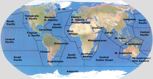
Zoogeographic regions
The names and approximate boundaries of the 26 marine zoogeographic regions used throughout this book are:
Arctic Northern Hemisphere seas 41°F (5°C) or colder
Antarctic Southern Hemisphere seas colder than 36°F (2°C)
North Pacific open Pacific north of the Tropic of Cancer
Central Pacific open Pacific between Tropics of Cancer and Capricorn
South Pacific open Pacific south of the Tropic of Capricorn
Temperate Eastern Pacific coastal seas from the Alaskan Peninsula south to Point Conception, California
Tropical Eastern Pacific coastal seas from Point Conception, California, south to the Ecuador-Peru border
Chilean coastal seas from the Ecuador-Peru border south to Cape Horn
North Atlantic open Atlantic Ocean north of the Equator
South Atlantic open Atlantic south of the Equator
Argentinean coastal seas from Uruguay south to Cape Horn
Amazonian coastal seas off northern Brazil, from Guyana south to Rio de Janeiro
Caribbean shallow coastal seas including the Gulf of Mexico, the Bahamas, and the Caribbean Sea
Western North Atlantic coastal seas from Newfoundland south to Key Largo, Florida
Eastern North Atlantic & Mediterranean coastal seas from Norway south to Senegal
Western African coastal seas from Senegal south to the Angola-Namibia border
Southern African coastal seas surrounding the Cape of Good Hope, from the Angola-Namibia border to southern Mozambique
Central Indian open parts of the Indian Ocean
Madagascaran coastal seas from Madagascar north to Somalia
Arabian coastal seas surrounding the Arabian Peninsula, including the Red Sea, Gulf of Aden, and Persian Gulf
Indian coastal seas surrounding the Indian subcontinent, from Pakistan south to Sri Lanka and east to Burma
Southeast Asian coastal seas surrounding Thailand, Indonesia, Borneo, the Philippines, and Taiwan
Western Australian coastal seas from Australias North West Cape south to Spencer Gulf
Southeast Australian / New Zealand coastal seas from the southern extreme of the Great Barrier Reef south to Spencer Gulf
Northern Australian coastal seas from Australias North West Cape around the north coast of New Guinea to the southern extreme of the Great Barrier Reef
Japanese coastal seas around the islands of Japan, including the East China Sea, Yellow Sea, and Sea of Japan
In addition to zoogeographic regions, shark distribution can be divided into ecological units by habitat type. The planets hydrosphere can be divided into many sub-categories of aquatic habitat. The system used here divides shark habitats into ten basic types. These habitat types are named and defined as follows:
Intertidal Zone near-shore areas subject to periodic exposure to air due to tidal movements
Estuaries near-shore areas where fresh water from the land mixes with salt water from the ocean; includes mudflats, salt marshes, mangrove forests and certain partially enclosed bays
Sandy Plains coastal areas featuring flat expanses of bottom covered by sand or silt, either unvegetated or supporting seagrass beds
Rocky Reefs areas featuring rocky reef-like structures that may be interspersed by sandy areas; includes coastal areas over the continental shelves and offshore areas on the continental slope and abyssal plain
Kelp Forest areas with a hard (often rocky) bottom supporting concentrated patches of kelps and other macroalgae
Coral Reefs areas featuring coral reefs, including fringing reefs, barrier reefs, and atolls
Open Ocean epipelagic zone of offshore areas, seaward of the continental shelves
Deep Sea mesopelagic zone of offshore waters, seaward of the continental shelves and generally deeper than 600 feet (200 metres)
Polar Seas areas at high latitudes colder than 41°F (5°C) year-round
Fresh Waters freshwater rivers and lakes that are predominantly affected by the terrestrial environment
This system of zoogeographic regions and aquatic habitats, imperfect as it doubtless is, provides a means of codifying and studying shark distribution patterns. Using this system, we can examine in a systematic and refinable way where each species of shark lives. Since each shark species is adapted to functioning within a range of physical and chemical parameters, each inhabits a characteristic habitat. By examining the biological opportunities and constraints of each habitat and how representative shark species make a living in that habitat, we can begin making sense of shark distribution patterns.
